
The the utilities sector, the vital need for speedy asset intelligence to support the maintenance of dependable infrastructure, and the ability to respond to outages quickly and with minimal downtime demands a comprehensive geospatial solution that delivers accurate, actionable data in near-real time.
Tuesday - 11 March 2025
Teledyne Geospatial has created an easy workflow that delivers near-real-time asset location intelligence to enable efficient outage response through the provision of up-to-date information about affected assets. Enabling accurate data empowers response teams to arrive at an outage site with the appropriate tools to minimize downtime. Accurate asset location data also facilitates streamlined equipment replacement when needed.
In the utilities market, the convergence of Digital Twins and lidar technology is proving to be a game-changer. This powerful combination is reshaping how utility companies monitor, analyze, and optimize their assets, ushering in an era of unprecedented precision and reliability. Pointerra3D is a cutting-edge AI driven platform that allows organizations to create and manage digital twins.
For the utility sector, the inspection and analysis of 3D virtualized assets in real time provides answers to asset and vegetation management questions. “Generating 3-dimenionsal digital twins of electric utility networks is now considered a necessity, enabling inspection and reliability teams to assess the full vertical structure of pole assets, and attached wire configuration.
Critical to generating a full 3D inventory of the assets is sufficient point cloud density to apply highly automated approaches to constructing the virtual model. Increases in point cloud resolution supports a more complete model—creating a clearer picture of the asset components and their health to support more accurate network-wide risk profiling,” said Greg Itzstein, Head of Product at Pointerra.
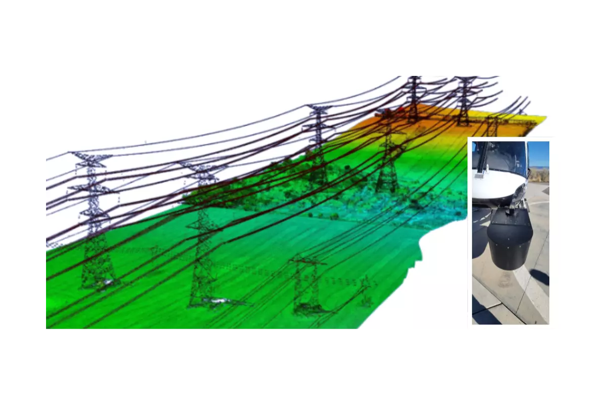
High-resolution lidar point clouds of utility assets deliver a 3D representation of infrastructure and surrounding objects to enable the fast identification of risks to assets, and public safety. Network Surveyor delivers actionable data efficiently, easily, sustainably, and economically. Image courtesy of Network Mapping Group.
High-resolution lidar point clouds of utility assets deliver a 3D representation of infrastructure and surrounding objects to enable the fast identification of risks to assets, and public safety. Network Surveyor delivers actionable data efficiently, easily, sustainably, and economically.
The OPTECH Network Surveyor lidar sensor is a robust system designed specifically for the utility market. It excels at capturing all features within transmission and distribution wire zones in a single pass, even at high altitudes, and without any compromises. Additionally, the system demonstrates excellent vegetation penetration capabilities.
Teledyne Geospatial has revolutionized airborne lidar for utility applications with the Network Surveyor’s groundbreaking Galaxy Onboard solution. By shifting data pre-processing from the office to the aircraft, Galaxy Onboard enables the production of geometrically corrected and spatially accurate lidar data in real-time while still in the air. Upon landing, users gain immediate access to this valuable data. The LAS v1.4 format point cloud generated by Galaxy Onboard is seamlessly integrated into any digital twin platform, and works with any lidar software tool kit, allowing for immediate post-flight analysis of high-risk geo-hazards to utility infrastructure. Teledyne Geospatial's Galaxy Onboard represents a paradigm shift in streamlining workflows and maximizing the utility of lidar data, offering unparalleled efficiency and real-time insights.
Furthermore, the Flight Management Software (FMS) has been redesigned with a primary emphasis on simplifying sensor operations. The new version facilitates the seamless entry of new users into the market, enabling them to quickly achieve efficiency, productivity, and success. Notably, the time required for user training has been significantly reduced from weeks to just days through the implementation of a tablet-based user interface.
Embedded in the edge processing solution and revamped user interface is a Quality Control system that delivers instant feedback to the sensor operator within the aircraft. This functionality allows for the immediate resolution of any data quality issues, ensuring that the data is captured according to the desired specifications. This not only minimizes the need for re-flight but also contributes to emission reduction, enhances the return on investment for technology, and ensures the resilience of the network.
The OPTECH Network Surveyor solutions signifies a remarkable advancement in addressing the requirements of the utilities market. These solutions not only enhance operational efficiency but also play a pivotal role in risk mitigation, ensuring system reliability, and ultimately bolstering the overall performance and resilience of utility infrastructure.
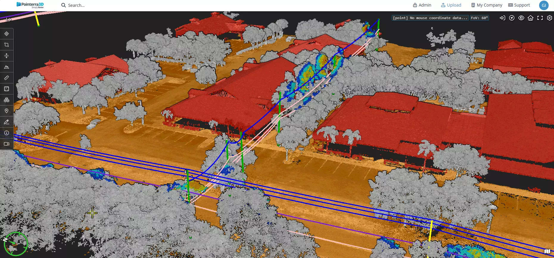
Addressing the need for speed in reacting to risk identification and mitigation, high-resolution LAS format point clouds from Network Surveyor are directly ingested into the Pointerra3D digital twin platform and support immediate vegetation encroachment analysis within mere hours of flight. Image courtesy Pointerra3D.
Jennifer Parham - [email protected]