
Discover how West Coast Utility reduced their training time and mobilisation efforts while collecting 10 times more data to the previous year.
Monday - 20 October 2025
The project’s expansive territory was in an environmental and seismic-sensitive geographic area with over 1.5 million utility pole assets. When alerts go out across this geographic region, there is a need to map and analyze the area in question in a rapid response situation, as it is critical to ensure public safety.
Deploying mapping technology within existing aircraft platforms has traditionally been challenging. Training personnel to effectively use these systems presents another hurdle, as does the ability to quickly derive actionable insights from the data - especially within the same day to support timely safety interventions.
To address these needs, they required a solution that can deliver lidar and camera data as fast as possible; they came to to support this technological requirement.

A complete technology solution was needed to address the challenge. It needed to be in a pod and compatible with the utility’s aircraft platform, the A-Star AS350 helicopter. The pod was required to integrate a high-performance lidar sensor capable of long-range detection in mountainous terrain and dense vegetation typical of the west coast, along with a built-in RGB camera. The lidar and cameras needed to be easy to use and produce data in the same day for rapid response applications.
Network Surveyor checked all these requirements. It includes the Galaxy Edge lidar, PhaseOne RGB camera options, Onboard Real-Time processing/QC and Teledyne full-time customer support.
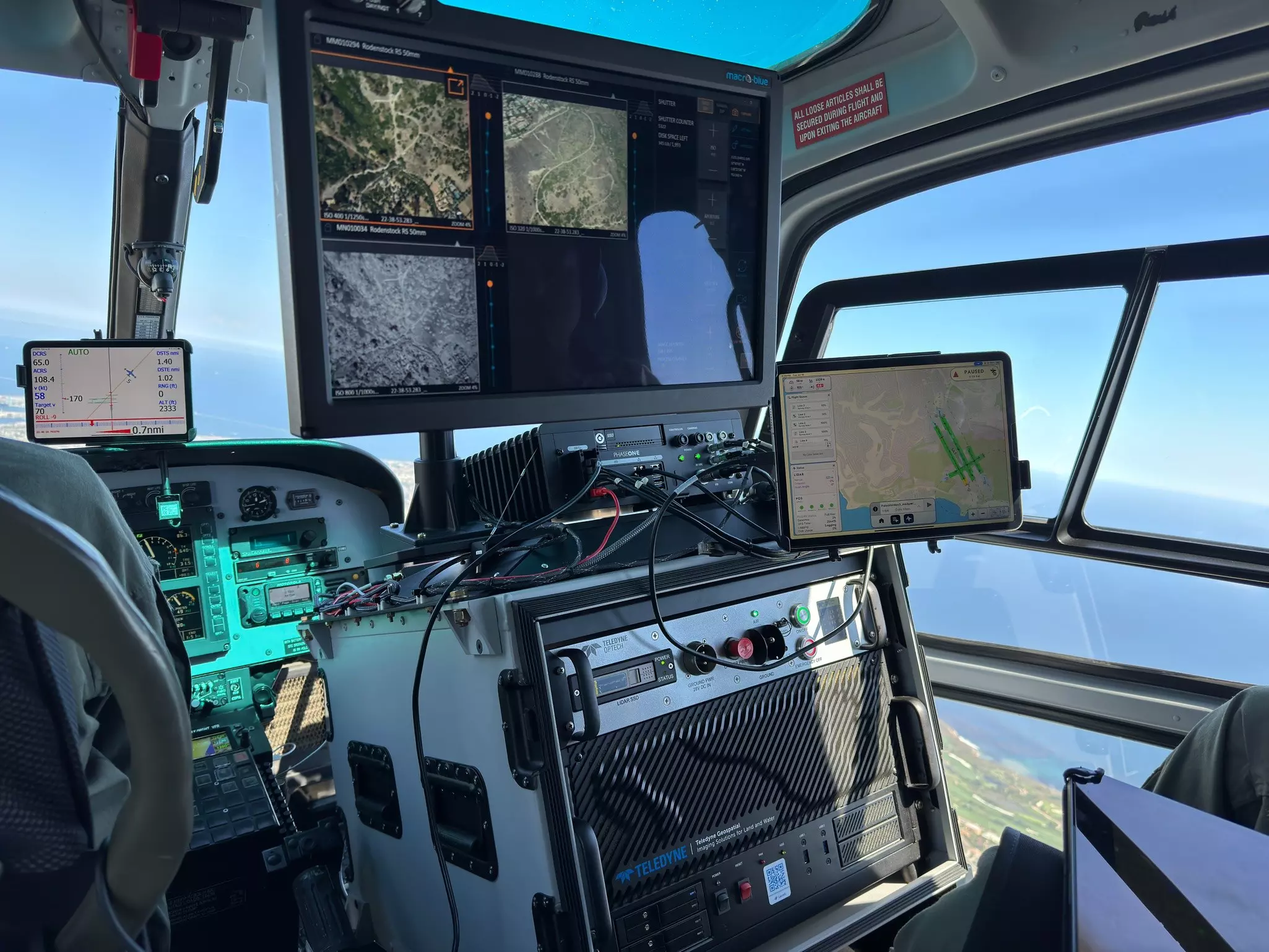
The utility was an adopter of Teledyne lidar solutions in 2020 to support their geospatial program and this incremental roll out saw early success and a desire to grow and expand their use of lidar technology into day-to-day business operations. When Teledyne launched Onboard for Galaxy, a state-of-the-art Flight Management Solution, they trusted Teledyne to improve their operations.
Lidar Program Manager: “Training has become easier with Onboard. The user interface simplifies data interpretation during surveys. Previously, our operators had to use multiple software applications to get the job done. Now, all functions are integrated. This allows operators to quickly interpret real-time feedback and act on data quality issues in flight, Onboard enhances efficiency and saves time for our flight teams.
“Onboard was the right tool at the right time, we went through growing pains with training and complex FMS software. We went through the upgrade to the Onboard FMS and boom, we took off. It was just night and day
for us.”
With Onboard, real data can be made available for rapid response to floods, fires, and landslides, which the service area is prone to these types of natural disasters. Having a rapidly deployable sensor with real-time processing provides insights into asset conditions immediately after landing.
Seismic Resiliency Program Lead: “Imagine an earthquake happens today, and we have no pre-event lidar. I can do a lot with the real-time LAS data to assess a substation or asset. All I need is a point cloud, and if you can land and hand me the data right away to look at, I’m a happy camper. These are very exciting developments, consider me eager to be an early adopter of that technology.”
“The OPTECH Network Surveyor is a game-changer for seismic resiliency and vegetation management. Its high-resolution lidar data accurately maps ground fissures and tracks land movement, providing crucial insights
for re-energizing properties and maintaining situational awareness. We are also using lidar to monitor wildfires.
These data products enable us to swiftly respond to incidents and ensure the safety and reliability of their
infrastructure.”
Discover how OPTECH Network Surveyor delivers fast, reliable insights - learn more here.
The integration of Galaxy Onboard has significantly reduced training time, enabling operators to be proficient after just 1-3 practice flights.
Minimized mobilization by allowing real-time quality checks, reducing the need for reflights and saving costs.
Scaled up data collection tenfold in lidar flight hours, collecting 10 times more data compared to the previous year.

Discover how West Coast Utility transformed aerial mapping operations with exclusive details on the technology and workflow improvements - available by downloading the full case study here.